Know exactly where your water stands.
A water right means nothing in isolation. Its fate hangs on the seniors above it, the calls on its river, the ditch that carries it, the land it serves. The state’s records were never built that way.
Ark-GARI rebuilds millions of state and county records — every decreed right, well, ditch, deed, parcel, and owner across nine Colorado counties — into one living model of the water system they describe, drawn on the real terrain in 3D. It already knows how Colorado water works — priority, calls, ditches, decrees, augmentation, title — so you can just ask, and every answer cites the record behind it. Not a filing cabinet of rights — the water system itself, connected.
- →Who holds the senior right on this stream — and who gets curtailed when they call.
- →Every decreed right on a parcel or in an owner's portfolio, with its priority date and decreed use.
- →Is there enough water for this use — adequacy, augmentation, and substitute-supply exposure.
- →Which ditch or canal serves this parcel — and the rights behind the headgate.
- →Abandonment risk — which rights sit on the decennial list, and why.
- →The decree itself — every diversion record traced back to the water-court order behind it.
Nine counties across seven river corridors — the Arkansas, South Platte, Blue, Eagle, Roaring Fork, Clear Creek, and Colorado headwaters — spanning Water Divisions 1, 2 & 5.
Under development The water-rights database is under development — additional counties are added regularly. Coming soon: Gilpin, Gunnison, and Saguache counties.
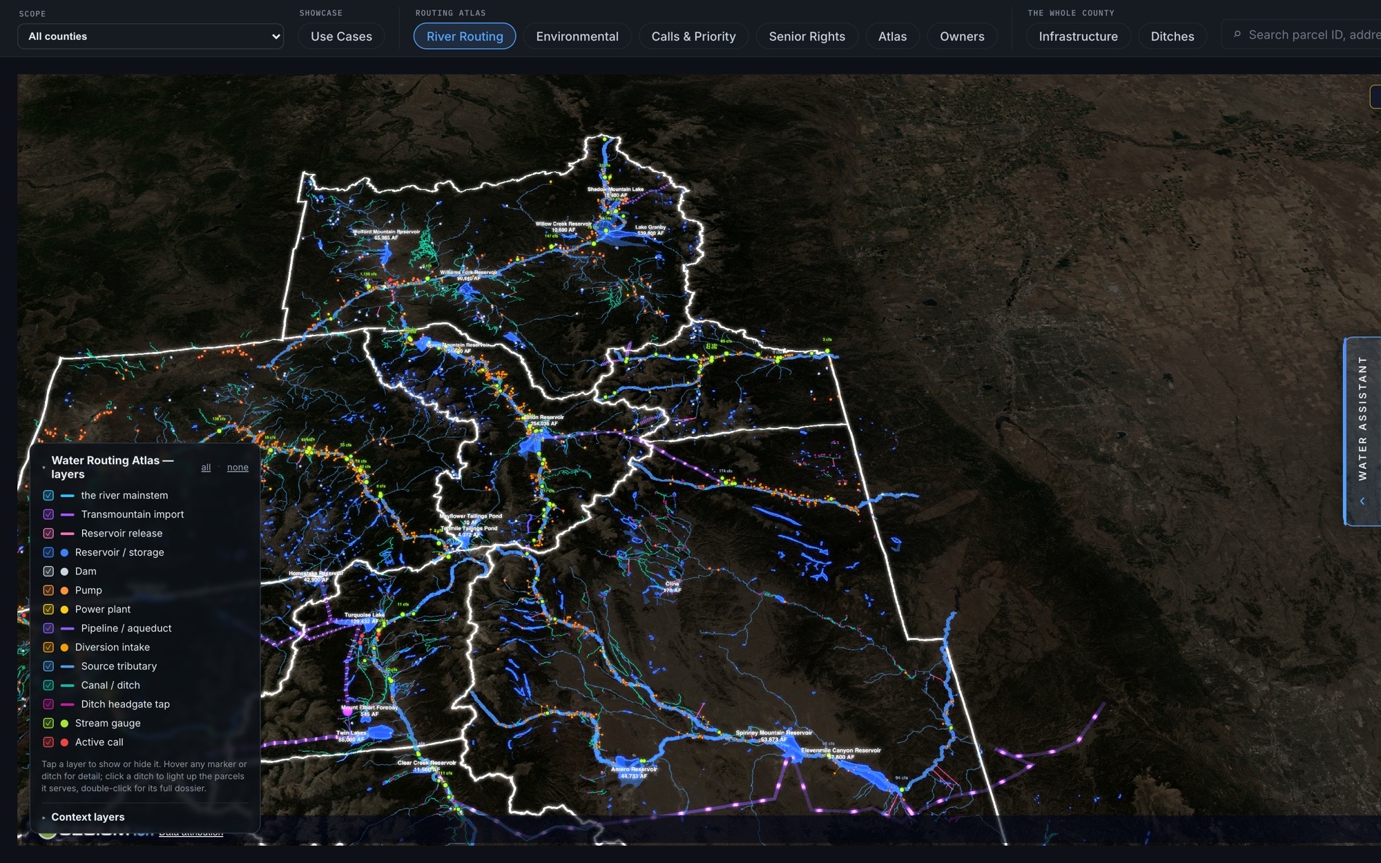
The Water Routing Atlas
The whole network in one view — transmountain imports, reservoirs, diversions, canals, and stream gauges drawn on the real terrain, with active priority calls lit in red. Every line is a real structure you can open to its decree.
Ask in plain English — every fact comes from the record
Type a question the way you would ask a colleague. The assistant runs queries against the same records the rest of Ark-GARI is built on — decreed rights, cases, calls, ditches, parcels, owners — and writes its answer from what those queries returned. Every fact in an answer is pulled deterministically from the graph, never generated: an answer that cannot cite a query from the same turn is blocked before it reaches you.
Grounded, or blocked
The language model writes the sentences; the graph supplies the facts. Names, dates, and amounts come from queries run while your question is being answered, and a draft whose figures do not match what those queries returned is discarded and rewritten. If the record does not hold the answer, it says so. The assistant’s own configuration — which skills and sources each persona may use — is stored in the same graph it answers from.
Runs on infrastructure you control
The default engine is an open-source model, and the graph it answers from is a self-hosted database — the whole stack runs on infrastructure you control, with nothing rented from an AI vendor. Questions, records, and answers stay on that stack unless you pin a hosted engine yourself.
Search every decreed water right on record
Fill in any combination of criteria — county, division, district, structure type, decreed use, structure name, WDID, case number, water source, decreed amount — and press Search. Results come back one row per decree, most senior first, with exact totals. Two searches no other public tool runs: follow a river upstream onto its tributaries, and search around a street address. Expand any row for its recorded court filings and a year-by-year diversion history; any WDID opens the full dossier.
One row per decree
A ditch is not one water right. Searching “Murray Ditch” returns three rows — separate decrees from 1869, 1882, and 1968, each with its own priority number, decreed rate, and uses. In the example, the 1869 decree sits on the state abandonment list while the other two stand clear — standing is per decree, and the search shows it that way.
Filters, forgiving identifiers, CSV
Narrow further by decree class (absolute or conditional), decreed use, abandonment-list status, live call status, and recorded recent use — or widen a name search to a structure’s recorded aliases. Case numbers and WDIDs are formatting-forgiving — “06CW32” also finds rights filed under “06CW0032”, and the interpretation is shown with the results. The whole match set exports to CSV with plain-English headers.
Every decreed right carries its own diligence
Select a water right and Ark-GARI opens its dossier — decree and priority, usability and risk, calls, and substitute supply. Because the right is tied to its parcel and owner, that dossier also carries the diligence that decides whether you can rely on it. Every facet is the water's — not a generic parcel report.
Search every water-court case on record
Fill in any combination of criteria — case number, division, county, structure name, WDID, water source, adjudication year, or words from the decree text — and press Search. Results come back one row per case: the rights it adjudicated, the structures and counties they sit in, the earliest adjudication date, the case’s most senior priority, and the imaged documents on file where they exist. Expanding a case lists every right it adjudicated, most senior first, with the court’s documents underneath.
The imaged decree, where it exists
Where the court’s paper record has been imaged, the case carries its documents — decrees, referee’s rulings, applications, and supporting filings — each with a page count, an OCR-confidence figure, the document itself as a PDF, and a link to the DWR microfiche it came from. The tab states how many cases carry imaged documents so far; coverage grows as the imaging campaign proceeds.
Forgiving case numbers, whole-set export
Case numbers are formatting-forgiving — “06CW32” also finds the case filed as “06CW0032” — and the search shows how it read them. Searching the decree text reads the imaged records, and the results say so when only part of the record can be reached. The whole match set exports to CSV with plain-English headers.
Live environmental conditions for every region
Ark-GARI tracks the conditions around each region’s water: drought class, active wildfires and smoke, streamflow, snowpack, reservoir storage, ditch diversions, and administrative calls. The readings come from the agencies that publish them (US Drought Monitor, NIFC, NOAA, NWS, DWR, NRCS), and every panel shows how old its data is. A briefing at the top lists anything severe.
Every active call — who is calling, and who is curtailed
Ark-GARI lists every administrative call in effect in a region: rollup tiles for active calls, juniors curtailed, sources under call, and the most senior caller; a short plain-language brief; the full call table; and the calls released in the last 30 days. Expand any call to read the curtailment cascade — every junior right the call reaches, in priority order, from DWR’s administrative-call records.
Active calls
One row per active call: the calling structure, its water source, priority date, the date the call was set, and the number of junior rights it curtails. Sortable by any column; most juniors first by default. Expanding a row shows the call record and the owner of record.
The curtailment cascade
Inside an expanded call: every junior right the call reaches, most senior first, each with its priority date and decreed rate in cfs or acre-feet; conditional rights are flagged, and juniors the ranking can’t reach are disclosed, never hidden. The junior list in the screenshot is redacted past the first rows.
Recent releases
Calls that came off in the last 30 days: the caller, its water source and priority date, the date the call was set, and the date it was released.